Sign up for our free monthly news and lucky draw alerts |
ADVENTURE Nepal treks: climb every mountainWith sweeping political changes, Covid receding - and new roads - Nepal is accessible again. You will now be able do the tough, high-altitude Annapurna Circuit trek without a US$20 Maoist receipt. And, amazingly, WiFi is available up in the rarefied air. by Daffyd Roderick updated by Jane McLean and staff reporters SEE ALSO Brunei Guide | Kathmandu Guide | Andaman Islands | Delhi | Goa | Himachal | Ladakh | Mumbai | Rajasthan | India Spas | Bhutan Guide 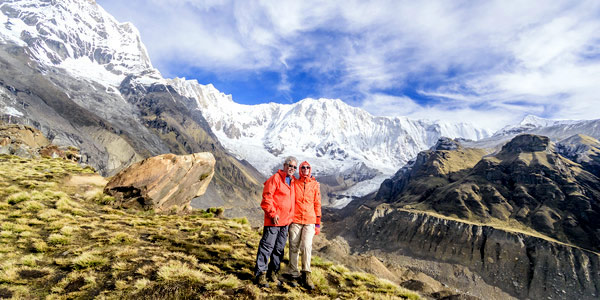
The Inner Himalayas beckon at the Annapurna Base Camp, a stiff hike from any direction. But the beautiful landscape and wilderness is well worth the aching muscles/ photo: Dev Gogoi 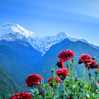
Sunrise at Chomrong/ photo: Dev Gogoi IT's 5.30am, pitch black and snowing as we begin the longest day of our trek. The halogen beam from my headlamp catches a furry yak in the eye and he grunts, possibly asking what the hell we're doing up so early. A good question. Today we do Thorung La, a high pass and the toughest day of the Annapurna Circuit, and we need to make an early start or we'll still be walking when the sun goes down. This is the day everyone talks about, worries about and plans for in the days leading up to it. Will the altitude make me sick? Will I slip off the icy trail? Will my knees make it down the other side? The 1,200-metre climb to the top of the 5,450m pass and the 1,600m descent down the other side begs a lot of questions. Not only is it a tough climb and a knee-grinding descent, but the thin air at this altitude also makes it mentally grueling. We walk single file, our boots making potholes in the fresh snow, grimly aware that trekking in Nepal is no walk in the park. Send us your Feedback / Letter to the Editor Halfway to the top we hook up with Ralph, a Tasmanian friend we met along the way. While the trail is less steep here, it is now less than a foot wide and skirts a long fall into steep, snow-covered terrain. This morning's snow combined with the trekkers ahead of us has polished the trail to a high gloss. My wife, Lisa, who hates walking on slippery gravel is surprisingly at ease on the ice. So at ease she fails to notice that I am slipping further behind her with every step. Send us your Feedback / Letter to the Editor {Guesthouses along the lower trails provide clean, if spartan, bedding with chicken curry and rice for just US$3 a night - with WiFi... I dig my walking poles in for each skittish jerk forward, my eyes searching the trail for bits of gravel for my boots to cling to. Sweat pours down my back as I try to keep my eyes off the plunge to my right. Ralph, who brought an ice axe – which I had earlier mocked – stands beside Lisa and watches me until I catch up with them. They are both kind and exchange comments about how slippery it was. 
Above Pokhara/ photo: Vijay Verghese The Annapurna trek continues. Now the trail rises and falls over a series of false summits. We pass several trekkers suffering from altitude sickness and soon Lisa begins to feel the effects of the thin air, panting for breath with every step. But before it becomes a serious problem, we're at the summit, celebrating with chocolate and water in a small shack. The wind is howling, flapping the prayer flags as we photograph each other. Soon the cold chases us off the pass and down the other side. All that's left is six hours of walking until lunch and another week of trekking. Every day is an adventure on the Annapurna Circuit, possibly the world's most famous trek. It is the place where the Dutch word "trek" became synonymous with "hike". The circuit wraps around the Annapurna range, a collection of mountains, anchored by Annapurna 1, which is 8,091m high. The peak was climbed in June 1950 by Frenchman Maurice Herzog and represented the first ever 8,000-metre conquest. Trekkers doing the complete circuit go counter-clockwise to avoid altitude sickness. Another good reason to hike in this direction is that lodging and food seem to improve on the far side of the pass, and it's better to go from good to great than great to good. Trekking the complete Annapurna circuit takes between 15 to 22 days, depending on fitness, adaptability to altitude and desire to linger along the way. While the trail has gained a reputation for being overrun with tourists, it had quietened with the rise of a Maoist insurgency in Nepal, post 9/11 travel jitters and the massacre of Nepal's royal family in 2000. Then, in March 2015, a narrow dirt road etched out of the moutain, was completed, linking the 97km from Besisahar - on the Pokhara-Kathmandu highway- to Manang in the Inner Himalaya. It's a gruelling and perilous 12-hour journey in a four-wheel-drive Jeep at roughly Rs5,000 for foreigners. The eye-popping Chamje-Tal Lake section is just a ribbon of rubble with overturned jeeps part of the scenery. The Besihar-Manang road has opened up this hidden district and cut the trekking time by around a week, but also put off some trekkers. The government responded by creating an off road hiking trail for purists. On the west, a jolting drive of a day will bring you from Pokhara to Jomsom and Muktinath though many prefer to fly to Jomson and then Jeep up. 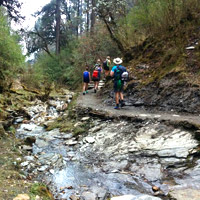
Walking a river trail after Pokhara/ photo: Joey Choi In the old days when Maoists prowled the countryside, some people questioned the safety of trekking in Nepal. But Maoists were not known to harm tourists though a fair bit of free-lance brigandage went on around the Annapurna Circuit. There were reported instances of trekkers being stopped, politely, by armed guerrillas and asked to pay "taxes" of around US$20 each. Trekkers were then issued official receipts in case they got hauled up again further along the way. Those who could afford it chartered a helicopter or small plane to fly from Pokhara to Jomsom and beyond. Yet, times have changed. Following a popular uprising, the Maoists joined hands with the government – defusing conflict – and the country's much vaunted constitutional monarchy went into full-blown retreat. The country's transition to a secular democracy (as opposed to a Hindu monarchy) continues to pose issues, debate, and protest. Yet, in April 2008 the communist Maoists swept into power, peacefully, following elections in Nepal. While that honeymoon ended by May 2009, the whimsical US$20 "tax" is now a thing of the past as the country continues down its avowed path to become a "capitalist democracy", a Switzerland of the East, perhaps to be followed, as classical theorists will opine, by communism, as originally adumbrated by Marx. Guesthouses along the lower reaches of hills will provide some modicum of comfort and spartan bedding with the de rigueur chicken curry and rice meals for an astounding sum of US$3 a night plus or minus - this, when we checked in during a trek in March 2016 for a story update. The places are clean, electricity is whimsical and, wonder of wonders, WiFi may even work weather permitting. Day 1 Pokhara – Besisahar – NgadiTo begin your stunning Nepal trek, take a taxi from Pokhara to a village named Besisahar. This is where the road ends and it's your last chance to make an international call for quite a few days. You'll find a lush green area, cut with small streams and tiny rice fields. The small village of Ngadi is a good first night's stopping point. (4 hours) Day 2 Ngadi – ChamjeClimb up the steep hill to the village of Bahundanda. A great lodge greets you at the top of the hill. The whitewashed brick village is one of the prettiest on the trail. Then the trail drops down to Syange, before it cruelly forces you to climb back up the slope to Chamje. Day 3 Chamje – BagarchapSome tough climbing today, through fields of marijuana, pastures of goats. Tal is a great little town for a break and it's wide streets and Dry Gulch atmosphere give it a very spaghetti Western feel. The trail then climbs steeply, across a suspension bridge and up to Bagarchap. Bagarchap was all but destroyed by a landslide in 1995 that killed many of the town's people and trekkers. It is a pleasant place to overnight in. (6 hours) Day 4 Bagarchap – Bhratang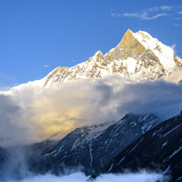
Machapuchare at sunset/ photo: Dev Gogoi This is a tough day of hiking and some people will want to stop earlier. There is some very steep terrain where the trail is narrow and loose. Bhratang is an old village surrounded by apple orchards and barley. There are only two inns and it is a good place for a quiet night. (6 hours) Day 5 Bhratang – HumdeThis day was one of my favourites, featuring a walk in a peaceful forest of pine and cedar. The high point is the view of the valley before descending into a wide open plain, dotted with small corrals for horses. We decided to stay the night in Humde, about an hour-and-a-half short of Manang. Tired from four long days, we found a great deck for lunch and decided to laze in the sun reading and relaxing. (4 hours) Day 6 Humde – ManangA short day that passes through the village of Braga. Recurring signs throughout the trek advertised the Braga bakery, promising the world's best cinnamon buns and coffee. We marched up to the door only to find a "Closed until Thursday" sign. This forced us to figure out what day of the week it was. Tuesday. Waiting around two days for cinnamon buns was out of the question. An hour later, we arrived in Manang home to the most Bavarian bakeries this side of the Black Forest. (2 hours) {Waiting two days for cinnamon buns was out of the question. But an hour later we found a stash of Bavarian bakeries Day 7 Manang Rest DayManang is at 3,600 metres and a two-day stay here is necessary in order for your body to acclimatize. During the trekking season lectures are held here each afternoon by the Himalayan Rescue Association. All you need to know to get safely over the pass is shared here. Acute Mountain Sickness (AMS) is the official name for the various forms of altitude sickness. Loss of appetite, headaches and sleeping poorly are all signs of mild AMS. 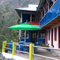
Trail guesthouses like this one are from US$3 per night / photo: Joey Choi Drinking at least three litres of water per day and going no higher until symptoms stop is the only treatment. It is possible to take a pill called Diamox to aid in acclimatization, but consult a doctor first. Day 8 Manang -Yak KharkaThe hike up to Yak Kharka at 4,200 metres, is steep and brief. The air grows thinner and colder and soon there is little aside from grass for vegetation. The Gangapurna Lodge offers a warm place to bed down for the night. (3 hours) Day 9 Yak Kharka – Thorung PhediNot a long day, but you really feel the gain of another 350m. The Base Camp Lodge at Thorung Phedi is built at the edge of a tall cliff and peers out across the valley below. There is a "High Camp" lodge that will save you an hour of climbing the next day, but it is cramped and uncomfortable. (3 hours) Day 10 Thorung Phedi – JharkotThis is the big day. The trail is closed in bad weather and with good reason. A slip can have horrible consequences. If the sun smiles on you, you're in for incredible views all around. It takes about four hours to reach the summit from Thorung Phedi, with many false summits on the way. The higher you go, the more barren the landscape is until at the top it is nothing but scree and rubble. Once you reach the prayer flags at the summit, the day really gets tough. The descent to Muktinath is a brutal 1.6km vertical plunge that lasts close to five hours. The mustard yellow and rust brown hills of the Mustang district offer visual distraction. Stop for lunch at Muktinath, but if you can force yourself to move after eating, the old city of Jharkot is only about an hour away and is another 200 metres lower. (10 hours) Day 11 Jharkot – MarphaWe opted to skip the old town of Kagbeni for a direct route to Marpha, famed for its apple pie, apple brandy and beautiful architecture. It's best to leave early for the hike up the valley to Jomsom as the wind picks up in the afternoon and blows straight into your face. Jomsom is home to an airport where those in a rush can catch a flight to Pokhara. It's a sprawling, charmless army town and while it's a welcome rest from the wind and dust, it's better to move on to Marpha. I've made no recommendations about guesthouses up to this point as they seem to all be equal, but in Marpha I must make an exception. The Nehru Guesthouse had food and service of a quality above and beyond anything else on the circuit, or in Kathmandu for that matter. The manager is a wonderful woman who seems to know what you want before you do. (7 hours) Day 12 Marpha – Kalopani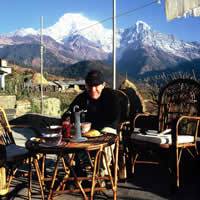
Author, Daffyd, pauses for a cuppa Our Nepal trek continues with a pleasant day of walking on good flat ground. The only mistake you can make is to take the local shortcut and end up having to wade through the river. Twice. It saves you about 20 minutes but you end up with frozen feet. Kalopani has amazing views of Dhaulagiri (8,167m), Tukuche Peak (6,920m), Nilgiri Central (6,940m), South (6,839m), Annapurna I (8,091m) and Baraha Shikhar (7,647m). (4 hours) Day 13 Kalopani – TatopaniThis is a tough day, covering almost 24 kilometres and a stiff descent that will leave you in need of a hot bath. Good thing that Tatopani translates into "hot water". The hot springs here are amazing and lure many trekkers into taking an extra well-deserved rest day. The Dhaulagiri Lodge has great rooms and is located closest to the hot springs. (6 hours) Day 14 Tatopani – GhorepaniThis is another tough day with the climb back up to Ghorepani taking close to six hours. It's steep and there isn't much in the way of places to stop for tea. But the reward is Poon Hill in Ghorepani. Many people do short treks coming from the opposite direction to see the view from the top of the hills. It's one of the best sunrise views on the circuit and is worth the pre-dawn hike to take in the entire Himalayan chain, especially Dhaulagiri and Manaslu. Day 15 Ghorepani – HilleThis is another tough day of downhill and you're bound to run into an army of shiny fresh package trekkers coming the other day, wheezing their way up the hill to Ghorepani. According to porters, this descent has close to 1,000 steps and your knees will really feel it. Day 16 Hille – Birethani – PokharaA short hike along the burbling river through rice terraces will take you to Birethani, the last checkpost on the Annapurna Circuit. From here it's a quick hike out to the scuzzy highway town of Beni where you can catch a cab to Pokhara to celebrate your journey. Send us your Feedback / Letter to the Editor FAST FACTS / Contact List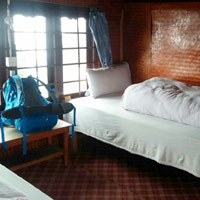
Pokhara area trekker guest houses are clean and spartan - expect chicken curry and rice meals/ photo: Joey Choi Safety: It is advised to register personal information and plans with respective embassies. Buy travel insurance that covers the cost of a helicopter rescue. The TIMS (Trekkers’ Information Management System) card was introduced in January 2008. The card is a safety initiative by the Trekking Agents Association of Nepal (www.taan.org.np) and the Nepal Tourism Board (NTB), whereby trekkers’ details are stored on a database with the card carrying personal information. A card can be obtained from NTB or TAAN offices in Kathmandu and Pokhara, or through government-registered trekking companies. You’ll need a copy of your passport and two passport-sized photos. Booking a trek: There are dozens of tour operators in Kathmandu and Pokhara that can organise treks. Trekkers are advised to arrange treks through a government-recognised agency. For more information, check Nepal Association of Travel and Tour Operators (www.natta.org.np). ACAP Fee: The entrance fee to the Annapurna region can be paid in ACAP (Annapurna Conservation Area Project) offices in Kathmandu or Pokhara. Hiring gear: You can hire all the things you need for the trek – warm sleeping bags, coats, jackets, gloves, and so on. In most of the stores the equipment is in really good condition, and it will be a waste of money to buy those things solely for the trek. It is recommended to hire equipment in Pokhara. There are plenty of shops that rent trekking gear in the "lake side" area of Pokhara. Porters: If you don't have much hiking experience, it is highly recommended to take Nepali porters with you. But keep in mind that these hard-working men and women speak little or no English and that the agencies that hire them out often pass on only a small fraction of your cash to the people carrying the load. The International Porter Protection Group (www.ippg.net) based in Kathmandu is a great source for information. They also run a clothing bank that supplies porters with clothing suitable for the mountains free of charge. 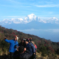
Now isn't this a great selfie spot? / photo: Joey Choi Any porters you employ are your responsibility from the moment you hire them until the trek is finished. They are very strong, but they are human. Every year porters die from altitude sickness, either because no one notices they are ill or they need the money so badly that they aren't willing to quit. If you want to hire someone to carry your load, do so, but be responsible. Rates can vary on porter tips, starting say at US$5 per day and up depending on loads and route severity. Money: It is almost impossible to exchange money during the trek. Change money at banks in Kathmandu or Pokhara, or try moneychangers who offer marginally better rates. Take enough Nepalese rupees with you on the trail. The exchange rate is roughly US$1=NRs106. Getting there: Nepal Airlines has flights from several Asian cities. Also spot Indian Airlines, Air China, Biman, Dragon Air (now rebranded as CathayDragon), Druk Air, Etihad Airways, Hong Kong Express, Jet Airways, Korean Air, Silk Air, MAS, and Thai Airways. Season: From late September until the end of December you will find the best views and most reliable weather. March and April are also popular trekking months, though they can be very wet. General information: The poverty of the average Nepalese means children will be found begging everywhere. Giving in only encourages more begging. If you want to do something, bring school supplies and give them to the teacher at the school. Or bring extra first aid supplies and drop them off at one of the rudimentary health posts along the way. They will be much appreciated and go a lot further than candy. The full circuit can be hard work even for the fittest because of the effects of altitude. Easier (and flatter) walks are available around Mt Annapurna. Acute Mountain Sickness or AMS can be fatal. Don't leave home without altitude medication such as Diamox and relevant vaccinations. Symptoms include headache, dizziness, nausea, loss of appetite, swelling of limbs, and fatigue. Keep up fluid intake to stave off altitude sickness and never ascend too rapidly. Water purification tablets are essential but prefer boiled water. Eating meat on the trail is not recommended. For visa and other information check the official website for Nepal's consulate. Useful links:Annapurna Conservation Area Project. Tel: [977-61] 521-102, fax: 528-203, (www.visitnepal.com/acap).
NOTE: Telephone and fax numbers, e-mails, website addresses, rates and other details may change or get dated. Please check with your dealer/agent/service-provider or directly with the parties concerned. SmartTravel Asia accepts no responsibility for any inadvertent inaccuracies in this article. Links to websites are provided for the viewer's convenience. SmartTravel Asia accepts no responsibility for content on linked websites or any viruses or malicious programs that may reside therein. Linked website content is neither vetted nor endorsed by SmartTravelAsia. Please read our Terms & Conditions. |